Google just rolled out a new feature to Google Maps / the Google Maps API:
Hybrid Maps! It’s a combination of the satellite photos and the map data which ends up A) looking very cool and B) being very useful. A sample image can be found below:
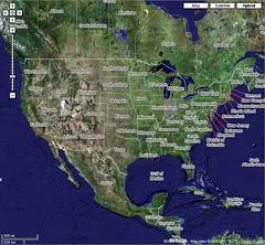
Google just rolled out a new feature to Google Maps / the Google Maps API:
Hybrid Maps! It’s a combination of the satellite photos and the map data which ends up A) looking very cool and B) being very useful. A sample image can be found below:
Posted: July 22nd, 2005
Comments are closed.
Comments are automatically turned off two weeks after the original post. If you have a question
concerning the content of this post, please feel free to contact me.


Jobins Joseph (September 11, 2007 at 7:05 pm)
i would like to search in googles